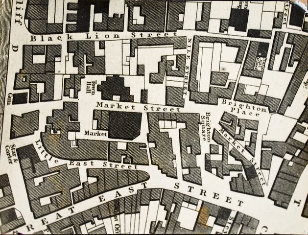
This is an enlargement of a map of the centre of Brighton, in 1824-25. The scale of the enlarged map is almost 96 feet to an inch.
At this period the market was on the east side of Market Street and the Town Hall and the original workhouse were in one building on the west side. With the removal of the workhouse to Church Hill (now the Buckingham Road area), the market was demolished and the present Town Hall erected on the east side of the street in 1830. In the same year a new Market Hall was built west of the Town Hall.
The National School for Boys in the Lanes was opened in February 1818. The Post Office at 67, East Street, was only there for 5 years, from 1822 to 1827, when it was transferred to North Street. The Gun Inn facing the Cliff was removed in 1824 and later replaced by Harrisons Hotel. Mahomed’s Shampooing Baths can be seen on the edge of the Cliff, south-east of the Star & Garter.
One notable feature not shown on this map is Prince Albert Street, which was driven through the area from Ship Street to Market Street in 1843
Image Reference: JG_08_095.tif
Date: 1824
Image Details: Copy
Size of Original: 237x176
Place: Brighton
Additional Information: No comment
This image is copyright and is made available for personal study only. Commercial reproduction in any media is prohibited without written authorisation.
High resolution images for commercial use are available. Please contact The Regency Society